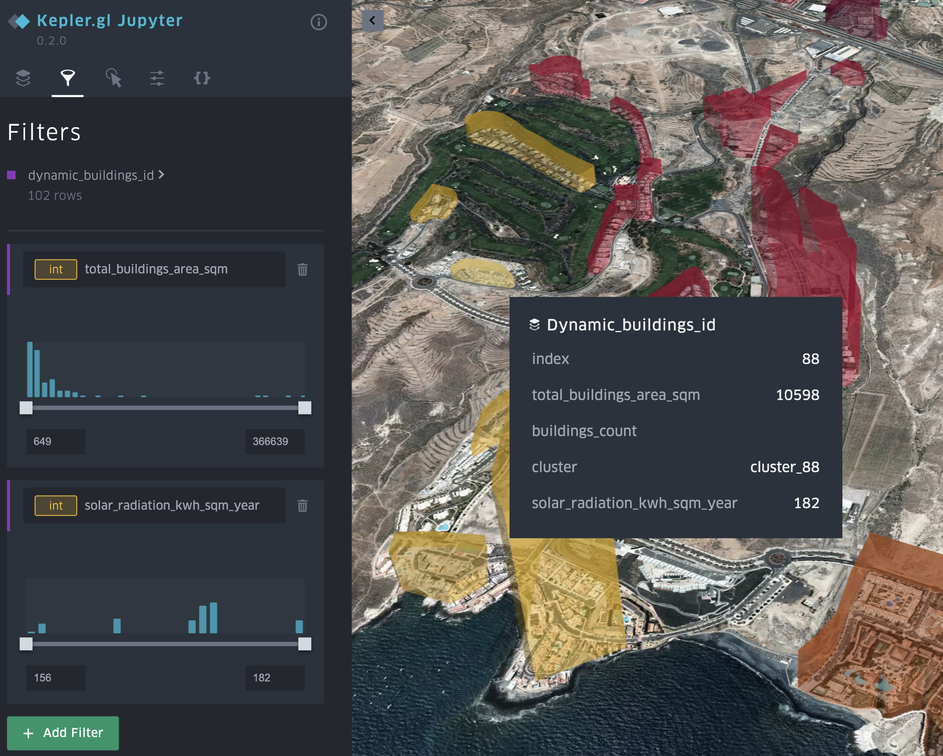
In a client project, I developed a solution that analyses countries and specific areas for the potential of Renewable Energy Communities. Energy communities are defined in the EU Renewable Energy Directive (RED II) as a way for private households to produce and consume renewable energy without being discriminated against by energy distribution system operators. This means that an energy community should be able to produce clean energy e.g. through solar panels on the roofs of some members and share it with other members through the distribution network with less costs and regulatory hurdles than currently exists.
To find interesting areas in a country, I selected different characteristics: Socio-economic characteristics such as population density or ‘green’ attitudes, and the average annual solar irradiation in a given area. On a more detailed level, these areas were analysed by looking for interesting residential areas by clustering private buildings and calculating their potential for solar energy through their aggregated roof area and solar irradiation. The results are displayed via Kepler.gl, a great tool for sharing and visualizing 3D maps.
The entire analysis is implemented in Python, using Pandas and Scikit-Learn for data analysis and clustering. Specific geospatial data was collected from OpenStreetMap and transformed into tables in PostGIS. Socio-economic data was imported from official government sources. Solar irradiation data was obtained from the EU database PVGIS.
Based on my analysis the Adeje Verde project in Tenerife chose the music school as the central building for solar panels providing renewable energy to the neighbourhood.
In a PoC I developed a geospatial data analysis and machine learning solution to help operators find the best locations for new charging stations. In the past charging stations were often built in front of town halls and other places just for prestige but these were not good locations for drivers.
The solution calculates for each potential location a set of geo-referenced features that are of interest for new charging stations, such as the number of existing charging stations within a certain radius, whether it’s in a large car park, whether it’s in a residential, shopping or business area, and so on.
On the other hand, the training data for the machine learning model is generated from real usage data of the charging stations. Specifically, the number of visitors or users per day is used as a label for the model.
In the end, the machine learning model predicts the use of the charging station at a potential new location. In addition, ‘Explainable AI’ is implemented to interpret the predictions made by the machine learning models so that it is possible to visualise why a new location is considered a good location, i.e. which features contributed most to a particular prediction.
The solution is developed in Python, Pandas, Scikit-Learn and some GIS libraries and runs on Azure with Docker and PostGIS.
Attribution
The charging station image is licensed by Wolfmann under Creative Commons Attribution-Share Alike 4.0 International, CC BY-SA 4.0 via Wikimedia Commons